From Woody's Couch

Our Playbook on OSU History

Category: Frozen Friday (page 2 of 10)

Frozen Fridays: ‘W’ is for Wilkins!

This blog post is part of the Frozen Friday Series, an A-Z journey of the Polar Archives.  Each week, we will feature some aspect of the history of polar exploration with a blog post written by our student authors. This week, it’s a blast from the past! Last year, Autumn Snellgrove interned at the Byrd Polar and Climate Research Center Archival Program and worked with new materials acquired by the program. In short, she scanned and researched these materials and wrote two blog posts about them. This is one of them.

In June of 1930, the famous explorer Hubert Wilkins, accompanied by Sloan Danenhower found themselves sorting through a Navy scrapyard, examining submarines for a trip under the North Pole. The Navy had given Wilkins his pick of the scrapyard, with the chosen submarine to be leased for only one dollar. The submarine in the best condition was O-13, which also held the record for the deepest dive. The pair, however, were spooked by the number 13, so “letting superstition overcome logic, they settled on the O-12.”[i] Unfortunately, the O-12 would prove as unlucky as they feared 13 would be.

Sir Wilkins and his wife Lady Susan waving to a
crowd,

Wilkins proposed a trip into one of the last uncharted places on Earth. He planned to travel by submarine underneath the North Pole from Norway to Alaska. The expedition would be called the Wilkins-Ellsworth Trans-Artic Submarine Expedition. Such a journey was fraught with risks. The Arctic holds no land beneath the ice and is composed of shifting ice floes which occasionally collide and shoot spikes into the ocean. Worse, everything that sailors usually rely on to navigate —the deep basin, the currents, the thickness of the ice, the temperature, its interaction with other oceans—was uncharted in 1930. For Wilkins this was part of the attraction; the ability to aid science, to learn about weather and “to fill in the last unknown on the map”[ii] drove his ambition and excitement for the journey.

Navigation in the uncharted Arctic was not Wilkins’ only obstacle, however. The O-12 itself, rechristened the Nautilus (with ice, as champagne was still illegal), proved to be one of the greatest challenges. The O-class submarines were built for coastal waters, not the Arctic or even, as Wilkins would discover, the open ocean. This meant that the submarine would have to surface every day to recharge its batteries and gain fresh air in a stretch of ocean that was uncharted and plagued with constantly shifting ice floes. If the submarine was unable to find a safe place to surface, the crew only had three days of emergency air before they would suffocate (partially explaining the trip’s nickname of “the suicide club”). These issues were compounded by the number of modifications necessary for the Nautilus, including fixing the engines, finding and caulking all leaks and preparing it for scientific experiments.

In spite of these problems, the newspapers hailed the expedition as ‘The Greatest Adventure in History.’ A flood of individuals applied to join the crew, children gave pennies to help fund the project, and there was a scheduled rendezvous with the Graf Zeppelin when the Nautilus resurfaced in the Pacific.  The trip itself, however, was not to fulfill the expectations of its newspaper headlines.

Ray Meyers, Chief Radioman aboard the
Nautilus, saying goodbye to his wife and
daughter.

Tragedy befell the expedition even before the submarine departed the U.S. While entering New York, Willard Grimmer, the quartermaster, was swept overboard by battering waves and drowned. This unfortunate accident was not the only disaster, either. During its first deep sea dive, the Nautilus sank and got stuck in the mud at the bottom of Long Island Sound. Though the submarine eventually dislodged itself, this was not the last time that the crew faced death within the Nautilus, as the entire trip to the Artic lay ahead of them.

Only three days into the journey, a storm hit. The Nautilus was not designed for the fury of the open ocean. As a result she pitched and rolled to the point that even Wilkins, the most experienced explorer on board, became seasick. During this expedition, the Nautilus and its crew barely escaped death on several occasions. At one point, water seeped into one of the engines. Left unchecked, the engine would have punched a cylinder through the side of the submarine, sinking the ship. With no lifeboats on board, the sunken sub would have served as a tomb for the entire crew. This crisis was averted due to the quick reflexes of the chief engineer, Ralph Shaw. At another point, with the ship now running on only one engine, the crew nearly suffocated when a wave slammed the tower hatch closed, threatening to create a vacuum in the submarine. Fortunately, everyone on board survived, owing their lives to an open forward ventilator. Then the worst happened: the second engine stopped, stranding the submarine in the middle of the Atlantic Ocean. The crew was without the power to restart the engine or even send a distress signal and they had no fresh air. Given the nature of the submarine and the bad weather, they were also basically invisible to any passing ships. The radio engineer, Ray Meyers, had to cobble together some of his equipment into a make-shift transmitter to send out the SOS signal. Nearly eighteen hours later the U.S.S. Wyoming came to rescue the stranded Nautilus, before towing it to Ireland. Four crew members subsequently quit.

Repair on the submarine, expected to take two weeks, took a month. Ever the optimist, Wilkins hoped all of the misfortunes to date meant that the expedition had already encountered all of its bad luck. This was not to be. Almost immediately upon resuming the trip, the Nautilus was besieged by yet more storms. It became clear that the Nautilus was too unreliable to safely complete the trip.

The dining room aboard the Nautilus.

Yet Wilkins remained determined and decided to submerge in Arctic waters. While the ship was preparing to dive, Commander Danenhower realized that the submarine’s diving planes were gone. Without these planes the submarine could dive under the water, but could not be controlled while submerged. This made the planned journey to Alaska impossible. Wilkins never investigated how or when the planes were lost but he, along with Meyers and a few other crew members, believed the ship was sabotaged by several of the crew members.  Given that only the diving planes were lost, while the vertical plane and the propellers were untouched, this rumor of sabotage seems very likely. Floating ice would not have been so selective about the damage it did.

Wilkins, however, would not accept complete defeat. To do so would mean personal and financial ruin. Instead, he decided to continue north. Recognizing the potential scientific opportunities from the beginning, Wilkins had two well-known scientists onboard to run experiments. Aided by the head scientist Harald Sverdrup, Wilkins collected some of the first data about the polar oceans, including mud samples and information about new ocean creatures. Wilkins did manage to force the submarine to dive to 37 feet by flooding part of the submarine and running into the ice, thus proving the possibility of under-ice travel, but the dive paled in comparison to his original plans. Later the expedition would be called “a landmark in science”[iii] but it did not satisfy the donors and readers eagerly awaiting news of Wilkins’ success.

After completing only a few dives, Wilkins was forced to leave the Arctic due to the Nautilus’ continued deterioration and the worsening weather. Wilkins had to face the worst storm upon his return, however, as he met his supporters and critics. Although Wilkins did prove that travel by submarine under the polar ice was possible, his trip was largely perceived as a failure, as people focused on the incomplete trip and not the scientific experiments.

Recently, over one hundred images documenting the Nautilus expedition were acquired by the Ohio State University’s Polar Archives in 2015 and join the larger Wilkins Collection held by the repository. These images span the entire expedition, from Wilkins and his wife Lady Suzanne waving at crowds  to images taken from under the ice in the Arctic.  Most of the images are of the Nautilus in the Arctic, many likely taken after Wilkins realized that he would be unable to continue the journey as planned. These images tend to depict the Nautilus as it arises from the ocean or as it is banked against the ice.

The U.S.S. Wyoming arriving to rescue the stranded
Nautilus.

Other images show the crew, the people who risked their lives to adventure; one is of the chief radio operator Ray Meyers holding his young daughter as she appears to kiss him goodbye; another shows a child sitting on the beds in the submarine; one even shows Wilkins and some of his crew posing for a funny picture, each man clutching their hats and laughing . Some pictures even showcase the very cramped conditions on the submarine, include what looks to be a picture of the dining area where there was so little room, that individuals had to eat standing up.

Perhaps some of the most remarkable of the images are those taken while the Nautilus was submerged under the ice. These pictures are the only ones in color, and they have short captions describing the situation and the ice. While these show little more than a deep blue sea and floating ice, they hint at the mystery and the danger the Nautilus and its crew faced while under the sea.

For more information about Sir George Hubert Wilkins or the Nautilus Expedition, please visit the Polar Archives.

[i] Nasht, Simon. 2005. The last explorer: Hubert Wilkins: Australia’s unknown hero. Sydney: Hodder Australia.pg, 215

[ii] Nasht, Simon. 2005. The last explorer: Hubert Wilkins: Australia’s unknown hero. Sydney: Hodder Australia.pg, 213

[iii] Nasht, Simon. 2005. The last explorer: Hubert Wilkins: Australia’s unknown hero. Sydney: Hodder Australia.pg, 247

Written by Autumn Snellgrove and published by John Hooton

Frozen Fridays: ‘V’ is for Vast Ice!

This blog post is part of the Frozen Friday Series, an A-Z journey of the Polar Archives.  Each week, we will feature some aspect of the history of polar exploration with a blog post written by our student authors.

The waters around both the Arctic and the Antarctic
are filled with floating chunks of ice.

Before his second expedition to Greenland, Robert Peary commented “The life up there under the Pole is terribly hard. We will be as much out of touch with the world as we would on some other planet. Some of us more than likely will never return.”[i] For innumerable polar explorers this proved to be too true—the scenes of their triumphs would become their tombs. Sometimes even the best sacrificed their lives to the hostile environment. In 1928, Roald Amundsen, greatest Polar explorer of his time and the first man to reach the South Pole in 1911, flew into the Arctic on a rescue mission and was never seen again.

No exploration is risk-free. One does not simply wander into a new land, hoping that all goes well. Polar expeditions hold their own special types of dangers and challenges. The stereotypical features of Polar Regions—the snow, ice and cold—prove to have a greater impact than is often expected. When explorers get into trouble there, seldom is anyone coming to help. A rescue team faces as much or more danger than the explorer they are trying to save. Admiral Richard Byrd understood this and refused to radio his companions when he found himself alone with carbon monoxide poisoning miles away from his base camp. He did not want them to risk their lives trying to save his.

The perpetually shifting ice-floes that surround the poles create one of the main threats posed to explorers. No ship or airplane can stand against a massive iceberg. Shifting ice can trap or crush a ship, preventing an expedition from even landing in their predetermined location, as explorer Earnest Shackleton and his Imperial trans-Antarctic expedition would discover to their misery.

Much of Antarctica is covered in snow and ice, as
one might expect. But not all of it.

In 1914, Shackleton headed to Antarctica with plans for “the first crossing of the last continent.”[ii] Soon after reaching Antarctic waters, however, Shackleton’s ship, the Endurance, became trapped in the ice pack. Like the Belgica before it, the ship and its crew survived a long, sun-free winter on the ice (where, through a mirage caused by the atmosphere, the crew saw the sun set twice in one day). The ship was not saved by the spring thaw like the Belgica, however. The newly mobile ice-floes smashed into the ship until it was completely destroyed.

Miraculously, Shackleton’s entire crew survived by crossing the melting ice and floating in lifeboats first to Elephant Island and then to a whaling station on South Georgia. The expedition’s epic quest to cross the continent ended without any member setting foot on Antarctic land.

Earnest Shackleton’s Hut with Mount Erebus in the
background.

Polar exploration was no safer for men on foot, who found themselves at the mercy of the perpetually shifting substance under their feet. Leads, which are channels of water caused by splitting or melting ice, can wreak havoc on an expedition. It prevents explorers from following their designated paths and can delay or end an expedition altogether. Arctic explorer Robert Peary, first claimant to the North Pole, seemed particularly unlucky in regards to leads.  Several times the inability to cross leads forced Peary to postpone or end his expeditions early. During Peary’s last expedition to the North Pole (1908-1909), leads developed in the ice around his camp and several inhabited igloos floated away toward open water. The stranded men were rescued when their ice island collided with the mainland. At other times thin ice could simply crack underneath a man’s feet and plunge him into the polar water, often fatally. In Antarctica, killer whales sometimes smash through thin ice (although thin is relative; killer whales can smash through over three feet of ice) to get seals. One of Shackleton’s men was nearly attacked by killer whales while traveling via dog sled over a thin patch of ice.

Traitorous ice is not the only threat, however. The air and temperature alone try to kill explorers.  “In Antarctica, shelter is more vital than food. Intense cold may kill more swiftly than any deprivation, save that of air.”[iii] Surprisingly, this is not because of the inherently cold air, but the persistent winds. In still air, the human body produces a small ‘bubble’ of warm air around itself, better allowing the body to maintain its temperature. Any wind blows this ‘bubble’ away and lowers the body temperature rapidly. Even burying under the snow is better than facing the wind. This wind, which is controlled more by the circular shape of the continent than by weather patterns, also causes blizzards. These blizzards can throw tons—literally—of snow into the air and proceed to bombard travelers and buildings with it.

Because of this, any shelter is better than none. Typically, expeditions would establish a base camp close to a coast and build permanent houses or igloos there. While traveling across the ice, away from their home base, explorers often take tents as a light, portable shelter. In a pinch, though, nearly anything that kept an explorer out of the wind could be used. When he landed on Elephant Island, Shackleton flipped his rowboats upside down and used them as a shelter for his men. Most of Shackleton’s crew lived in these makeshift houses for over one hundred days, waiting for Shackleton’s return. During Robert Scott’s fatal expedition to the South Pole, six of his men spent their winter living in a hastily carved ice cave after exploring too far from camp. Even such marginal shelters probably saved their lives, if only temporarily.

A shot of Antarctica taken on the way to Williams
Field from Observation Hill.

As can be expected in these conditions—conditions that humans are not meant to survive in—the human body suffers extensively. Explorers can develop frostbite from the cold, scurvy from an inadequate diet, and polar anemia from lack of sunlight. With enough supplies and knowledge these problems can be overcome, but few are safe from their threat. Robert Peary spent twenty years in the Arctic and lost eight of his toes. Dr. Frederick Cook was actually one of the first to identify and moderate both scurvy and polar anemia. Cook correctly surmised that scurvy comes from a poor diet and that eating fresh meat would prevent it.

A final, rather less obvious danger of polar exploration is extreme boredom. The polar regions do not inherently provide entertainment. Instead, explorers brought books and cards, and sometimes even balls to play games on the ice. You can find more information on Polar entertainment here. These diversions not only served to entertain people, but they also kept morale up—particularly for those expeditions which became stuck on the ice.

Visit the Byrd Polar and Climate Research Center Archival Program for more information about Richard Byrd, Frederick Cook or the many other polar expeditions held in our collection.

Written by Autumn Snellgrove and edited by John Hooton.

[i] True North, page 41

[ii] Reader’s Digest Antarctica, page 218

[iii] Reader’s Digest Antarctica, page 182

Frozen Fridays: ‘U’ is for Unknown!

This blog post is part of the Frozen Friday Series, an A-Z journey of the Polar Archives.  Each week, we will feature some aspect of the history of polar exploration with a blog post written by our student authors.

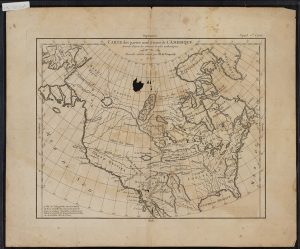
This is one of the oldest maps in the Polar Archives.
Dated at 1772, the map is a French map of colonial
North America, just before the American War for
Independence.

Humanity has by and large completed the map. The Earth has now been effectively mapped out such that there are no major blank spaces labeled with the phrase ‘hic sunt dracones,’ or “here there be dragons.” We take for granted the globe as we know it today.  It is easy to forget what it might have been like to wonder what mysteries those unmapped regions held. Just what was beyond that vast amount of water? Could there be a whole new civilization? Prosperous cities with bustling streets? Paradise? Or could there actually be dragons? Imagination may have run wild in the minds of some, out pacing reason. Tales of far off unexplored lands must have been comparable to our contemporary science-fiction vis-à-vis space travel.


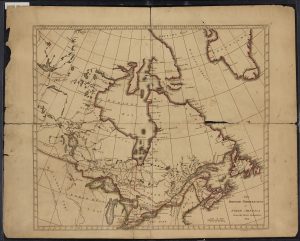
Another of the oldest maps in the Polar Archives,
this map is from 1814 and depicts what is now
eastern Canada.

For most of human history, there was great speculation over a southern continent. This speculation and desire to find it lasted well after the founding of the United States of America. This Terra Australis Incognita (‘southern unknown land’) was conceived as early as the sixth century BCE by Greek philosophers such as Parmenides and Aristotle. The Greeks held that the world is divided into five parallel climate zones: a northern frigid zone, a northern temperate zone, a torrid zone, a southern temperate zone, and a southern frigid zone. Their world, the Mediterranean region and parts of Afro-Eurasia known to them, consisted of the lands in that northern temperate zone. To the south, there must be lands to ensure that the world is not ‘top heavy’. The north and south lands were thought to be divided by a torrid zone, an area of fire and monsters that split the world.[1]

Many nations considered how the mysterious
southern continent might look. This map was
created by Germans.

These ideas of a southern continent persisted, but it was not until the age of European exploration that they were put to the test. As European explorers discovered foreign lands, they created a more complete map. Theories of the nature of the mysterious continent were put forth and ultimately disproved. Africa, long thought to be connected to Terra Australis Incognita, was proved not to be, as Bartholomew Diaz (1488) reached and Vasco da Gama (1498) rounded the Cape of Good Hope. South America too was thought to be connected to Terra Australis Incognita, but Ferdinand Magellan’s voyage through what would be called the Straights of Magellan (1519) and Francis Drakes’ voyage to where the Atlantic meets the Pacific south of Tierra del Fuego (1577) disproved that theory.[2] The idea that Terra Australis Incognita was connected to a larger landmass was killed in the late eighteenth century when Captain James Cook sailed south to find the mysterious continent. Cook spent over three years in unknown southern seas, hoping in vain to find it, unknowingly circling Antarctica. Cook returned to the United Kingdom with proof that Terra Australis Incognita could not be a parallel paradise that had once been dreamt up by the Greeks.[3]

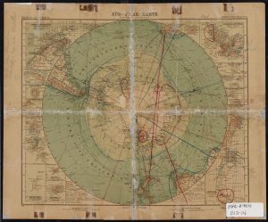
As one might expect, maps have become more
accurate as our technology has improved. However,
perspective can make a great deal of difference, as
this map from 1941 demonstrates.

By and large, Cook marked the end of humanity’s major ignorance of Antarctica. The chapter of Antarctic exploration dominated by myths finally closed. Although there would be further theories about the nature of the Antarctic interior, none would be quite like the mythos of Terra Australis Incognita. In the coming centuries, Antarctica would be revealed to mankind. In those chapters are the tales of Dr. Frederick Cook, Sir Hubert Wilkins, and Admiral Richard E. Byrd. Those and other accounts of polar exploration can be found at the Byrd Polar and Climate Research Center Archival Program. Some of those many stories are told here in other Frozen Fridays blog posts.

Written by John Hooton

[1] Antarctica, 2nd ed., s.v. “Terra Australis Incognita.” (Surry Hills: Reader’s Digest, 1990).

[2] Antarctica, “Terra Australis Incognita.”

[3] Antarctica, 2nd ed., s.v. “Antarctica Encircled.” (Surry Hills: Reader’s Digest, 1990).

Older posts Newer posts