Robert B. Gordon
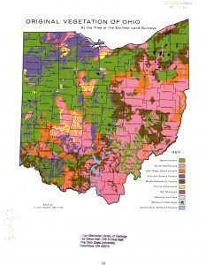
Original Vegetation of Ohio at the Time of the Earliest Land Surveys (1966)
Ohio Biological Survey, The Ohio State University Libraries Collection
Working as a graduate student under the guidance of Professor of Botany Edgar N. Transeau (1875-1960), Robert B. Gordon (1901-1981) continued efforts pioneered by Paul B. Sears (1891-1990) and reconstructed the original vegetation of Ohio using witness tree records of the federal land surveyor’s field notebooks combined with his own field surveys. This colored, comprehensive vegetation map displaying distinct vegetation types was the first of its kind in scope and methodology prepared for any state in the United States. The map was widely acclaimed and referenced. Gordon described his methodological approach to create this map in detail in his 1969 published bulletin The natural vegetation of Ohio in pioneer days.

