Paul B. Sears
The Natural Vegetation of Ohio. I, A Map of the Virgin Forest (1925)
Ohio Journal of Science, The Ohio State University Libraries Collection
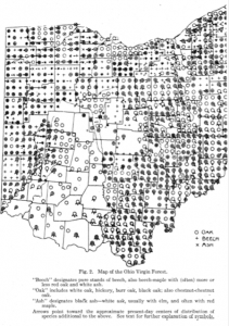
Appointed as an instructor of botany at The Ohio State University from 1915 to 1919, Paul B. Sears (1891-1990) was among the first to study botanical information derived from federal land surveyor’s field notebooks, namely the location of “witness” trees, which were prominent trees at or near section corners of surveyed subdivisions. Sears pioneered the method of “Vegetation Mapping” (first published in 1921) based on a set of symbols he created to use in natural vegetation maps. His map of the “Ohio Virgin Forest” was the first published map showing the original forest types and distribution of forest trees in the state.

